Brickworth Sand Quarry (2003-2023, still active)
A Whiteparish local history page from younsmere-frustfield.org.uk

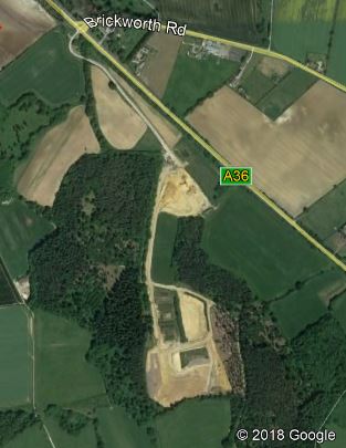

Four views of Brickworth Quarry from Google Earth in 2002, 2018, 2021 and 2022 (exact dates of photos not known)
Click here for larger 2018 image (opens in a new tab)
The first view shows the site before work started
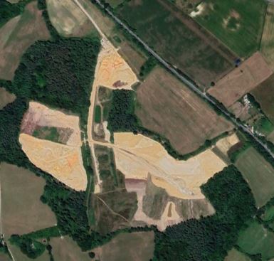
The third view shows areas at bottom left restored and new areas at bottom right started
In the fourth view, replanting can be seen on the grey inert fill at bottom left of the third image
The unchanging upper area is where the central buildings are and sieved sand is stored ready for loading
See Quarries for a link to other quarries of sand, gravel, chalk and clay in the parish, past and present.
Brickworth Quarry is run by Raymond Brown Quarry Products, with planning permission granted in 2003 and completion of restoration to farmland and forestry required by 2030 at the time of writing (2018). The quarry produces building sand and is an inert waste site, taking materials like chalk and subsoil from building and roadbuilding. The sand is from the Reading Bed formation that runs on through the village towards Meadow Court and beyond (see Geology page), although the bed changes from sand to clay half way down the hill to Meadow Court, a fact not captured by BGS (yet). After the topsoil and subsoil are stripped and stored the sand is extracted by a digger and filtered and screened to remove any particles above 5 millimetres and any clay, after which a conveyer lifts it onto the piles pictured below. From there it is loaded onto lorries. The sand deposits are up to 15 metres thick. After installing a clay lining, the inert waste is then used to restore the original ground profile. A few parts of the quarry were farmland and have already been restored, while the rest is being restored for forestry, the original conifers having been cut before work started. The replacement planting will be of native hardwood including oak, beech and hornbeam. Writing in 2022, initial phases of the site have already been restored to agricultural land.
Summary of activity
- 2003 The first planning permission for the site granted
- July 2009 Permission granted for an extension in for an area known as Round Copse North. This requires completion of restoration by April 2020
- April 2017 Planning granted for two further areas of minerals (to the east and west). It is estimated these areas will yield a further 1,340,000 tonnes.
- A planning application has been made for a small extension at Lowdens Copse for a further 170,000 tonnes to be extracted [source Raymond Brown website 2022]

If you buy building sand locally it probably comes from here. Photograph taken on 21st June 2018 at an open day.
Brickworth Quarry employs five people: a site manager, weighbridge operator and three machine operators driving diggers and a bulldozer. Additional temporary staff are brought in for major operations. At the open day on 21st June 2018 we were taken on a guided tour of the site, seeing all stages in the stripping, sand removal, clay lining, landfill and restoration of topsoil, as well as sections already restored.
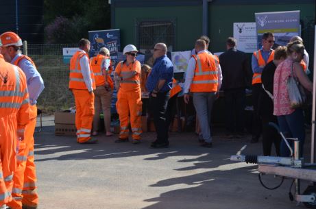

Staff and visitors mingling at the open day on 21st June 2018. As well as tours of the site there were displays and information booklets, activities and goodies for children and a steady supply of freshly baked pizza and hot and cold drinks to enjoy in the warm sunshine.
Right hand image (c) Raymond Brown
 small.jpg)
Sand extraction (photograph (c) Raymond Brown)
The first map below shows the approximate extent of the quarry overlaid on an old Ordnance Survey map, aligned to match the Tithe Map extracts below it. These maps were prepared using the 2018 outline of the planned area at the time - they represent the 2018 view at the top of this page.

The area on an OS 1:2500 scale Map, showing Brickworth, Newton and Moore, rotated to match the Tithe Map alignment below
The map below shows the approximate extent of the access road and quarry overlaid on the 1842 Tithe Map. Because the A36 has been realigned at Brickworth and now runs to the south of where "Gile's Eyre's pond" was, the quarry access road appears to start from the middle of nowhere on this map. The section of roadway linking the two quarry areas runs along the 1842 "Green Lane on Sandlands Drove", but other than that the lower (western) boundary, the quarry doesn't generally follow 1842 field boundaries. This lane is still a public footpath and appears to have connected the property of Moore Manor to Brickworth as well as providing access to fields along its route.

The area on the 1842 Tithe Map, showing Brickworth, Newton and Moore
Next is the Tithe Map with colouring to show landowners. All the land on which the quarry sits was part of Countess Nelson's inherited Eyre estate of Brickworth in 1842. To the south is land owned by Nelson, part of the "Grateful Nation's" contribution to the Nelson estate. As the last of the Eyres, the land owned by Countess Nelson became part of the Nelson estate on her death in 1878. Church Coppice, partly coloured in yellow (and green on the following map) [complete the colouring on the other tiles] lies just outside the quarry area. In 1842 it was owned by the Queen Elizabeth Charity and occupied by Stephen Parsons and Moses Welstead.

The area on the 1842 Tithe Map, showing Brickworth, Newton and Moore and landowners
The final map in this section shows the Tithe Map coloured to show occupiers of the land. It shows that in 1842 most of the land on which the quarry is situated was either in use by Nelson (pink) or farmed by John Bell (grey). Countess Nelson's Brickworth Park is visible to the left of the Brickworth road junction and she reserved use of Sandlands Coppice as well, both shown in a light sand colour, as well as a small area within the quarry area - Lime Kiln Row, parcel 743. Generally speaking the Tithe Map shows that Nelson and Countess Nelson didn't rent out areas of woodland, so it might be assumed that these were in use for coppice, timber and hunting.
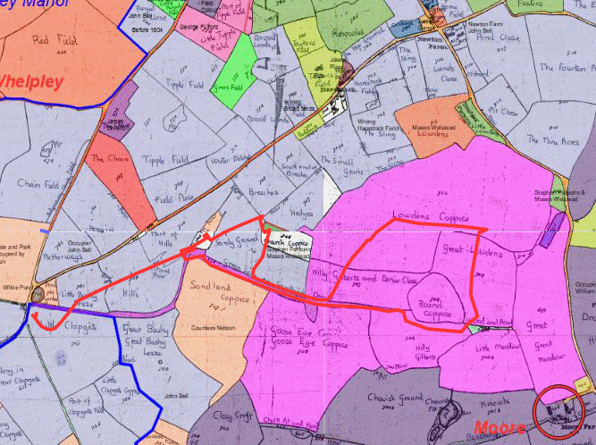
The area on the 1842 Tithe Map, showing Brickworth, Newton and Moore and occupiers